Makrinitsa – Stagiates
Distance: 5,8 km
Duration: 2 hours (net march time 1.40′)
Altitude: From 630 m. (Makrinitsa) at 285 m. (Kappa bridge) at 398 m. (Stagiates)
Signage: signs, red marks
Drinking water on the route: yes
This is a circular route, which from the square of Makrinitsa initially descends down the cobbled road towards Volos. Arriving at Koukourava, the lower district of Makrinitsa, it crosses the Mega stream by a stone arched bridge and ascends on a path towards Stagiates. From there, following a more easterly path-calderimi, it crosses the stream again and returns to Makrinitsa. Of course, the route can also be reversed, or only part of it. An important advantage is the stunning view of Volos, the sea and the verdant slopes of the ravine from many points.
From the square of Makrinitsa, next to the church to the west, there are two cobbled streets. The rightmost one ascends slightly at the beginning, going towards Sarakinos and Fytoko. We follow the wide cobbled road on the left, a real stone work of art, which descends with manoeuvres between the houses of the village.
We pass by the churches of Agios Athanasios and Agios Georgios and, as we approach the asphalt road, the cobbled road seems to turn right. But below is completely closed and impassable a few meters above the road, and so we continue straight on a concrete road, passing under the Stafylopati mansion and coming out on the asphalt road, which we follow for a hundred meters downwards. We find the continuation of the cobbled road on our left and further on we cross the road and continue downhill towards the Nano’s mansion.
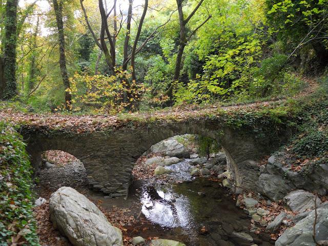
We pass a plane tree next to a fountain without water, and below we have two cobbled crossroads on the right that go downhill towards Volos. We continue straight ahead in a straight line, pass a fountain without water and another dry triple fountain with plane tree and then we descend to the asphalt road (there is a sign to Argyro Mansion at this point). Across the road there is a narrow concrete road going downhill. We follow it and immediately go right on a path, which brings us to the area of Tabakika at the Mega stream. Here there is the two-arched stone arched bridge of Kappa, next to the ruins of a tannery. As you can see in the photo, some stones are missing from the base of the eastern arch, raising concerns about the stability of the bridge. Hopefully action will be taken soon to repair it.
We cross the stream and two paths continue on the opposite bank. The rightmost one follows the stream going downhill towards Aedonololies-Agios Onoufrios. We take the left one that goes up the slope. Above we come out on a narrow uphill road that meets a junction and we go right. After a while we find the continuation of the path on the left and go uphill. Arriving at the first houses of Stagiates, we walk for a few meters on a cobbled street. It is best not to follow the red arrow that turns left, but walking a little more straight ahead in a straightaway, then go diagonally left on a cemented cobbled road with steps, which leads us to a concrete road. A few meters further up the road turns right and brings us to the church of Agios Athanasios in the square of Stagiates.
After cooling off at the old fountain with the Arabic inscription under the shade of the two large plane trees, we continue on a cobbled road crossing the asphalt upwards. As we come across another fountain, we turn left onto the paved road that further on comes out on the asphalt. After fifty meters we go diagonally right on an uphill concrete road, which leads to the nunnery of the Annunciation of the Virgin Mary. To the left of the entrance of the monastery, a narrow rural road continues and we follow it, seeing Makrinitsa in the distance. After some walking, where the road turns left, we leave it and continue straight on a path, which brings us to a wooden bridge, which was recently built by active residents of Stagiata. We pass the stream and as we go uphill the path shows parts of a cobbled path, to finally lead us to the entrance of Makrinitsa, on the plateau where the buses make a turn.


